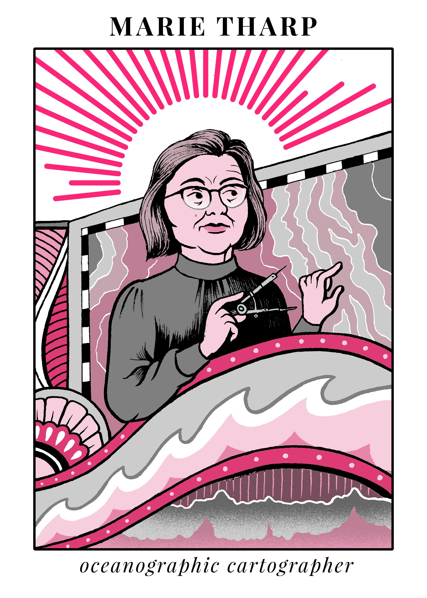
Four facts about Marie Tharp, the woman whose art mapped the bottom of the sea
She discovered the Earth's 'backbone' even though men wouldn't let her on a ship for 17 years
Matteo Farinella
You may have never heard of Marie Tharp, but if you've ever seen a map of our planet, you've probably seen her work. She single-handedly translated indecipherable columns of numbers recorded from 1940s-era ocean research expeditions into detailed, hand-drawn maps of the world's oceans. Along the way, she not only managed to discover the "backbone of Earth," a series of mountainous ridges deep below the ocean surface, she also found evidence in support of one of Earth's greatest phenomenons: continental drift.
1. Tharp seamlessly integrated science and art.
Her early childhood was spent accompanying her father, a soil surveyor for the U.S. Department of Agriculture, on his fieldwork trips. She earned bachelor's degrees in English and music from Ohio University in 1943 before going on to get a master's in petroleum geology from the University of Michigan, an opportunity which was only made available to women after college-aged men were sent overseas to fight in World War II. Tharp's mentors saw that she was a capable scientist, but also urged her to learn drafting (technical drawing), a necessary skill for female researchers at the time. In the earth sciences, this meant turning rows and rows of numbers (collected by male scientists, of course) into hand-drawn maps.

Matteo Farinella
After graduate school, Tharp landed a job in Tulsa, OK, as a geologist for Standard Oil and Gas. She spent her spare time studying for another bachelor's degree, this time in math. Her degree included a course in spherical trigonometry, in which she learned to plot mathematical objects onto round surfaces. This was arguably the most important class of her academic career, but, according to Hali Felt's biography of Tharp, she reportedly dismissed it as "sort of a comedown" compared to her other math courses. Ultimately, it was her drafting skills that landed her an earth sciences career in 1948, when she was hired as a research assistant in Maurice Ewing's laboratory at Columbia University.
2. She was a "grand dame of ocean exploration" who wasn't allowed to set foot on a ship for the first 17 years of her geology career.
Up until the 1960s, it was considered bad luck for women to be on naval ships. So while Bruce Heezen, her future collaborator, was given a prestigious position as chief scientist for a series of National Geographic-funded scientific explorations of the ocean floor as a college senior, Tharp was stuck in a cramped basement office in New York City crunching numbers and processing the raw data collected by male scientists.
The work was painstaking: the most up-to-date method of charting the deep ocean was a technique called sounding. An electronic signal was sent toward the seafloor, and a device on board the ship charted how long it took for a microphone in the ship's hull to record the signal's echo. The resulting data looked much like an EKG does, and it was Tharp's job to turn those numbers into a map. Her attention to detail and dedication to accurately sketching the ocean's vast ridges and trenches ultimately produced the World Ocean Floor Panorama, the first comprehensive map of the 70 percent of our planet's surface that is obscured by water.
3. In 1953, she made the stunning discovery of a 10,000-mile ridge in the middle of the Atlantic Ocean..
The Atlantic ridge surrounded a huge tear in the ocean floor similar to the topography of the Great Rift Valley in East Africa. We now know that such a rift is caused by the gradual separation of two massive tectonic plates, a hallmark of continental drift. But Heezen, four years her junior and still a doctoral student, disagreed and ignored the idea that the rift was evidence for continental drift as just "girl talk."
"When I showed what I found to Bruce, he groaned and said, 'It cannot be. It looks too much like continental drift,' Tharp explained in a 1999 interview. "At the time, believing in the theory of continental drift was almost a form of scientific heresy."
Almost everyone in the United States thought continental drift was impossible. Her theory was ultimately supported by an unlikely ally, famed ocean explorer Jacques Cousteau. He disagreed about the rift's existence and undertook an expedition to prove Tharp wrong. But when Cousteau's video evidence surfaced, the lava-filled valley surrounded by two sharp ridges was clearly visible, exactly where Tharp predicted it would be.
This, combined with evidence of earthquakes (caused by the movement of tectonic plates) in the same location, meant that her conclusion that the rift was evidence for continental drift could no longer be ignored. This development came as no surprise to Tharp, who was remarkably calm during the five years of debate over her interpretation of the data. In fact, she was so convinced that she was right from the get-go that she is famously quoted as saying about the men around her, "I was so busy making maps, I let them argue."
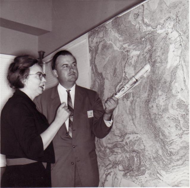
4. Like most female scientists of the era, she wasn't recognized for her work until very late in her life.
Tharp worked quietly in her crowded basement office at Columbia University's Lamont-Doherty Earth Observatory while Heezen (who earned his doctorate in 1957) presented their work at major international scientific conferences. Although this seems like a recipe for jealousy and conflict, it suited their personalities, and they grew very close. The pair eventually had a falling out with Maurice Ewing and instead secured funding through the U.S. Navy; Tharp was even finally allowed onboard a research ship for the first time. In 1997, the Library of Congress named her one of the four outstanding cartographers of the 20th century and, in 2001, she was awarded the first Lamont-Doherty Heritage Award for her contributions to oceanography. Today female earth scientists who want to work at Columbia University's Earth Institute can even earn the Marie Tharp Fellowship.
Tharp died of cancer in 2006 and so never got to see the honor that she may have enjoyed most: the Marie Tharp Historical Map layer in Google Earth.
In an era where female scientists were routinely dismissed as secretaries and human calculators, Marie Tharp's sharp mind and quiet determination allowed her to make huge waves. Her maps have shaped the way that we think about the Earth and offered support for the major theory of continental drift. They have doubtlessly also inspired generations of budding female earth scientists, driving them forth to explore every corner of the globe.