A map of Mars's ancient rivers unlocks new possibilities for learning about the Red Planet
The same tools scientists use to understand Earth's climate history may work on Mars, too

To find signs of life on Mars, many scientists believe ancient river systems are good places to look. That’s why in February, NASA sent its Perseverance rover to Jezero Crater, which is home to a massive delta at the mouth of a long-dry river.
But how do you find these valuable sites? That’s a problem scientists on Earth have only recently been able to solve.
NASA’s Mariner 9 spacecraft identified the first Martian river networks in 1971, during its historic orbits around the red planet. The craft was steadily sending black-and-white images of the planet, but it was only after a massive dust storm subsided that Mars’ stunning surface was revealed to the scientists eagerly waiting back on Earth. The photos showed canyons cut deep into rock — features the scientists recognized as clear signs of water.
Over time, imagery from Mars kept improving, but it was still piecemeal. Scientists needed more complete and higher-quality global imagery to study how vast and interconnected the planet's ancient river networks were; finding out where these rivers had flowed would point to potential landing sites. In 2017, NASA opened the doors to understanding Mars as a global system by releasing an eight-trillion-pixel mosaic image of Mars’ entire surface.
It took three years of poring over those detailed images to finally pay off. A new study, published in Geology in December 2020, is the first to take advantage of the complete mosaic. To explore the mysteries of Mars’s global river networks, Jay Dickson, a researcher at California Institute of Technology, and his colleagues mapped ridges left behind by rivers (fluvial ridges), which are essentially the inverse of a river channel.
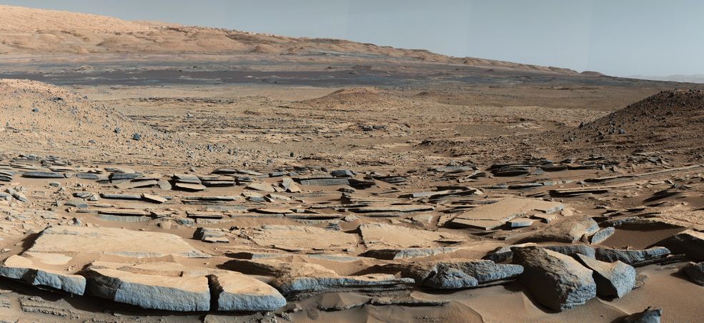
We often think of rivers creating valleys, like the broad Mississippi floodplains or steep walls of the Grand Canyon. How can a river form a ridge?
Rivers do two things: they erode material and deposit it somewhere else. As rivers cut, the only trace they leave is the absence of rocks that used to be there. Downstream from erosive channels, rivers can leave behind sediments, building up a record that can later — sometimes much, much later — be studied to understand the past environment. Those sediments form erosion-resistant ridges. Billions of years after Martian rivers laid such ridges down, Dickson was able to map them.
But how do you map a river ridge from space? The answer lies in the shadows.
Dickson and his colleagues determined which landforms are ridges by the way they cast their shadows. They identified 68 ridges on Mars, including over a dozen new ones, finally connecting the global dots of ancient Martian rivers, deltas, and lakes.

This view of channels on Mars came from NASA's Mariner 9 orbiter. In 1971, Mariner 9 became the first spacecraft to enter orbit around Mars
Overall, the researchers cleared up confusion about large-scale hydrologic processes.
“Before our global mosaic, we were only able to document [water and sediment movement] at the local scale,” said Dickson, who spent roughly three years stitching together the composite image. “Our work is showing a plausible explanation for how Mars worked as a whole. You had huge rivers over huge expanses that were depositing sediments all over the place," Dickson continued. "With the complete context of the surface of Mars, thanks to our mosaic, we can more confidently determine which are fluvial ridges... and which probably formed by another process.”
Most ridges that are still present on Mars formed over three and a half billion years ago, during the wetter part of the planet’s history, and are found almost entirely in its southern hemisphere.
“This [study] helps us understand the extent of these fluvial networks,” said Briony Horgan, a planetary scientist at Purdue University who was not involved in this study. “They’re helping fill in the map… in places that have experienced a lot of erosion, and you might not expect valleys to be left behind.” She added, “They’re filling in the gaps not just in space, but [also] in time. That can help us understand, was ancient Mars periodically habitable? Was it persistently habitable?” The next step is to send robotic and crewed missions to study these sites.
Deciding on a landing site for Mars missions, which is a collaborative effort among hundreds of scientists, is no simple task. Choosing a site takes years, beginning with an open call that brings in dozens of suggestions from the scientific community. Over months of debating, voting, and debating again, the teams slowly narrow down the list of possibilities by considering myriad factors based on the mission’s scientific goals.
“This is primarily... an astrobiology mission, and so the big constraints for a landing site are clear signs of an ancient, habitable, aqueous environment,” Horgan said. “It's a small subset of places." And for a sample return mission — like NASA’s ongoing Perseverance mission, whose rover successfully landed on Mars on February 18th — the site has to have a lot of diversity in terms of geological processes and mineralogy.
“[Fluvial] ridges are among the best targets to send rovers and, potentially, astronauts to study,” Dickson said. “These are deposits that record what Mars was like early in its history… [and] may have a more direct relationship to the global climate of Mars early in its history.”
Ridges in floodplains may also offer less of a logistical headache than alternative sites. “These kinds of deposits could occur in areas that are easier to land on because they’re big, flat plains,” Horgan offered. “That makes them a little bit easier to get to… If we can get to them, they should help tell us about what’s going on upstream.”
River features have already been targets for Mars research. NASA’s Spirit and Curiosity rovers visited Gusev and Gale Craters, respectively, both chosen for their abundance of fluviodeltaic (river and delta) features. According to Horgan, who is a co-investigator on the Perseverance mission, there are even some small ridges near the Jezero Crater landing site. The European Space Agency’s ExoMars 2023 landing site, Oxia Planum, was also chosen for its fluviodeltaic features.
Ancient river systems on Mars aren’t so different from what we see on Earth today, allowing scientists to compare the rock records and histories of the two planets.
“If you could wander around Mars when [these features] were forming, you’d absolutely recognize the landscapes,” Woodward Fischer, another Caltech planetary scientist on the study, said. “There would be some weird things about them, like they wouldn’t have plants. But you’d be right at home.” Look up the barren Atacama Desert or bone-dry Death Valley, and you’ll see river channels and ridges that bear a striking resemblance to their Martian counterparts.
Because rivers and their surrounding floodplains accumulate sediments that sit undisturbed for long stretches of time, their physical and chemical characteristics reflect processes and conditions at the planet’s surface. In Earth’s geologic record, scientists use these rocks to reconstruct what the climate, atmosphere, and biosphere were like millions — even billions — of years ago.
The same tools may prove useful on Mars, though we’re just beginning to chart the planet’s geologic record.
“Our understanding of the rock record on Mars is still really coarse, totally in its infancy,” said Fischer. “One of the biggest breakthroughs in the last twenty years is the recognition that Mars has a sedimentary record, which means we’re not limited to just studying the planet today. You can ask a question about its history. There are all these really interesting commonalities with the geologic records of early Mars and early Earth that I don’t think anyone was expecting.”