.png?auto=format&fit=max&w=3840)
Only eight hurricanes hit New England in 100 years. Soon more will head for Boston
Climate change is shifting storm paths, and new targets are underprepared

Scientists have been sounding the alarm for over a decade that climate change is bad news for anyone who lives in the path of hurricanes. With the destruction wrought by Hurricanes Harvey, Irma, and Maria just this past summer, the connection between climate change and hurricanes has become hard for anyone to ignore.
Hurricanes are becoming more frequent, and the season is lasting longer each year. With an increasingly warm ocean, hurricanes can spin with more devastating energy and carry more moisture to flood coastal cities.
Amid all this, a new study, led by climate scientists Andra Garner from Rutgers University and David Pollard from Pennsylvania State, found that climate change might be having an additional, unexpected effect on hurricanes: they're moving north, bound increasingly often for northern New England rather than the mid-Atlantic states. Hurricanes are on the move, and they’re headed for Boston.
Garner and Pollards’ team set out with the intention of finding out just how frequently New York City will flood in the future. In the five years since Superstorm Sandy devastated the area, several studies have looked at how intensifying hurricanes and rising sea levels may effect the US’s most populous city. One such study found that, by 2100, formerly 100-year floods may occur as often as every three years. But that finding comes with a major assumption: that hurricanes in the future will hit New York City at the same frequency that they currently do.
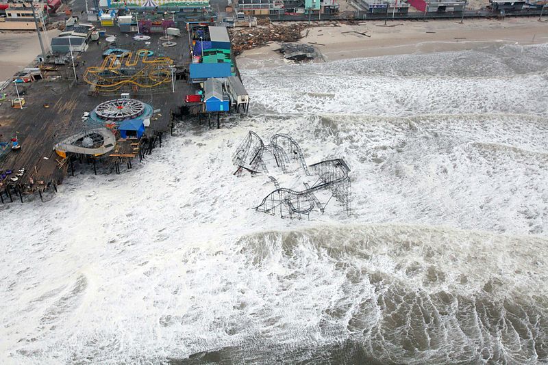
New Jersey after Sandy
Rather than make any similar assumptions, Garner and Pollard created their model from the ground up. Using a combination of global climate change projections, hurricane tracking forecasts, and sea level rise models, they simulated nearly 300 years’ worth of Atlantic hurricanes through a warming climate and rising seas. New York, they found, would experience a 500-year flood every five years by 2300. But it wouldn't be because of hurricanes; those were missing New York, passing by to the east on their way to New England.
The modeled hurricane tracks, skirting New York and the rest of the mid-Atlantic states before making landfall in Connecticut, Massachusetts, and Maine, were puzzling. Hurricanes that turn north of the Caribbean should eventually be forced to make landfall in the mid-Atlantic by an area of high pressure that sits just offshore. Only eight hurricanes in the last century have made landfall on the New England coast.
But thanks to climate change, that high-pressure zone may be weakening. A research team led by the National Oceanic and Atmospheric Administration looked at tropical storm tracks around the globe for the past 30 years, finding that tropical storms have slowly been shifting poleward in their respective hemispheres. This suggests that climate change is disrupting the balance of atmospheric pressure between land and ocean. This side effect of climate change was first pointed out in 2003, but the mechanism behind it continues to baffle scientists – and as a result, it mostly isn’t accounted for in hurricane models.
Garner and Pollard’s ground-up approach appears to have captured this global shift, however. And with the high pressure ridge off the US’s east coast expected to continue diminishing over the coming centuries, there’s no atmospheric nudge pushing hurricanes onshore before they intersect the New England coastline as it juts out into the Atlantic.
That’s bad news for New England – but it’s hard to say exactly how bad. That coastal communities in Connecticut, Rhode Island, Massachusetts, New Hampshire, and Maine are at risk of inundation from sea level rise comes as no surprise, but no one has looked at how hurricanes might amplify flooding in Boston in the same way that Garner and Pollock sought to do for New York.
In fact, one study that attempted to map the combined effects of sea level rise and hurricanes for the entire US East and Gulf coasts actually set the northern limit of their analysis at Connecticut. So where New York City planners are now equipped with estimates for maximum storm-induced flood heights, their counterparts in Boston – which now appears to be at an increased risk for hurricanes – are relying on underestimates based on sea level rise alone.
The historical rarity of hurricane landfalls has also left the region relatively unprepared for a major storm. For example, Massachusetts’ building standards only require homes within one mile of the coast to withstand 110 mph winds (the upper limit of a Category 2 hurricane) compared to 185 mph in parts of Florida. Moreover, that Massachusetts law exempts all homes constructed prior to 2009 – in a region famous for its historic coastal communities. In addition, huge swaths of Boston and eastern New England are low-lying coastal plain similar to Houston - by 2100, as much as $85 billion in property is anticipated to lie in Boston's 100-year floodplain.
The consequences of unpreparedness are hinted at by the beating New England took from storms earlier this decade. Irene, no longer a hurricane when it passed through the region in 2011, caused more than $700 million in damage in Vermont alone as normally placid creeks swelled to overtake entire towns. Six years later, residents there are still working to rebuild. The following year, Sandy infamously ravaged the Connecticut coastline and caused $360 million in damages. With the effects of potential future storms amplified by sea level rise and even higher wind speeds, that destruction could increase sharply from the next major storm.
The upside is that Garner and Pollards’ study, combined with the spotlight on hurricane preparedness shone by the historically bad 2017 hurricane season, may be the warning New England communities need to prepare and adapt. The same modeling approaches applied to New York to determine flood heights and frequencies can be used to update Boston’s inundation maps, and Houston’s tragedy may serve as a lesson other to cities about the unexpected risks they face from storms.
Climate change is changing everything about hurricanes, including their trajectories – and New England needs to prepare for a wet future.
Peer Commentary
Feedback and follow-up from other members of our community
Anna Robuck
Marine Science
University of Rhode Island
As Michael suggests, New England climate is noticeably in flux; the Northeast US has experienced a 70 percent increase in heavy precipitation events between 1958 and 2010. However, public awareness regarding risks associated with extreme weather and climate change has yet to fully embrace the implications climatic shifts holds for the region. Discussion of climate change and hurricane/NorEaster risks becomes even tougher given the current administration's penchant to scrub climate change from discussion and the recent muzzling of New England scientists poised to discuss the regional effects of climate change.
Yet despite these cultural and regulatory setbacks, researchers are moving ahead to better understand predicted changes to storm frequency and trajectory. Isaac Ginis from the University of Rhode Island Graduate School of Oceanography has made particular headway in the region, after developing a hurricane model predicting how an inevitable "worst case scenario" would impact Southern New England and metropolitan Providence...hint: the forecast isn't pretty.