Air quality monitors mounted on public transit see pollution other sensors miss
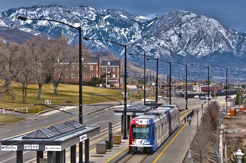
Researchers in Salt Lake City are using light rail trains to measure the city's air pollution

vxla on Wikimedia Commons (CC BY 2.0)
Every time I go outside, I check the air quality.
I use the United States Environmental Protection Agency’s (EPA) AirNow App, which grabs data from a nearby monitor located in downtown Los Angeles, about four miles from where I live. It’s a habit I picked up upon learning that poor air quality contributes to 100,000-200,000 deaths in the U.S. every year. City pollution is also a huge contributor to climate change, contributing over 75% of global carbon dioxide (CO2) emissions.
In order to reduce the impact cities have on our health and climate, the EPA and National Oceanic and Atmospheric Administration (NOAA) currently oversee monitoring stations across the US that measure both air pollutants and greenhouse gases. However, each instrument can cost over $20,000, and this limits the number each city can afford. As a result, approximately 120 million Americans currently live in a county without a single EPA small particle pollution monitor and, despite our warming planet, NOAA regularly monitors CO2 in only 17 states.
The growing need to fill in these monitoring gaps had led to a rise in the development of low-cost air quality sensors. Companies like Purple Air sell equipment that costs around $200 and they rely on community science to dramatically expand the urban air quality network for a fraction of the cost. That said, since this equipment is not as accurate or reliable as traditional monitoring stations, their data is seldom used when creating new environmental regulations. Plus, $200 is still out of reach for many low-income communities; even with these cheaper options, there’s still a lack of monitoring equipment in neighborhoods that are disproportionately burdened by air pollution.
But a new study published in Environmental Science & Technology has demonstrated that a new, lower-cost monitoring method exists that might revolutionize how cities sample air pollution.
It all started in 2014 when Logan Mitchell, then a postdoctoral scholar at the University of Utah, began sampling Salt Lake Valley air out of the window of a Transit Express (TRAX) light rail train. “We put the instruments in the driver’s cab right under [their seat],” Mitchell, now a research assistant professor, remembers fondly. Since then, they’ve upgraded their method, but the principle is still the same.
Sitting on the roofs of three TRAX trains are research-grade instruments (similar to what the EPA monitors use), which measure a suite of pollutants including nitrogen dioxide, ozone, fine particulate matter, methane, and CO2. The trains run along the corresponding Red, Green, and Blue Lines that transverse Utah’s Salt Lake Valley metropolitan area, which includes Salt Lake City and its suburbs. Mitchell explains: “By putting an instrument on a mobile platform, you’re able to get a lot more coverage. It’s equivalent to installing a whole network [of traditional air quality monitors] and...it’s a lot more cost effective.” That’s because, even though a single TRAX monitor has a price tag of $40,000 each, it's able to capture the same data as 30 stationary instruments, which altogether would end up costing over $1 million to install.
I think back to my local air quality monitor, four miles away from where I’m sitting right now. Even over the span of those few miles, there's an array of different emission sources ranging from freeways to auto body shops to oil wells. Pollution levels can also vary depending on wind direction, weather, and topography. There's a very real possibility that the air quality outside my home is different from what's being reported, but existing monitoring networks in my city are simply too spread out to be able to capture these small-scale changes in pollution. This is also the case in Salt Lake.
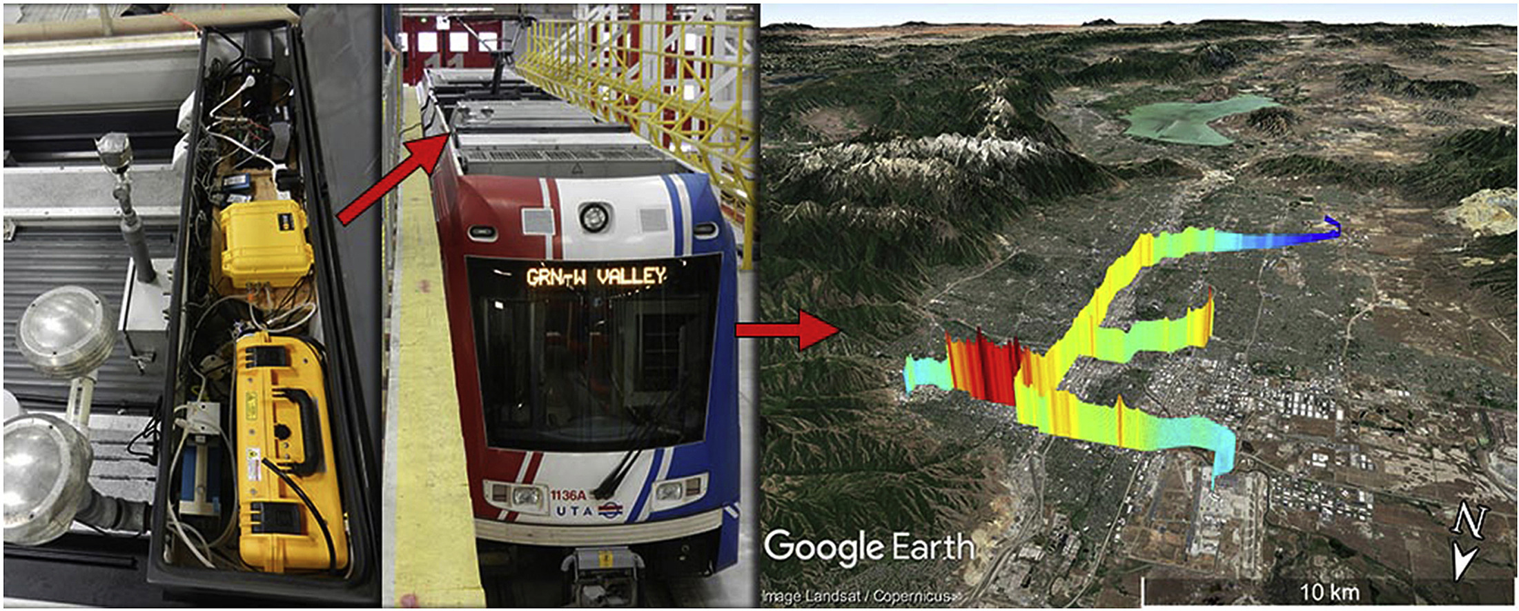
An air quality sensor mounted on a TRAX train, shown on the left, and a sample of the air quality data the monitor can produce
Mitchell et al 2018 (CC BY 4.0)
Similar to Los Angeles, Salt Lake City is notorious for its poor air quality, which is among the worst in the nation. Its growing population and resulting urban sprawl has also been linked with increased CO2 emissions in recent years. Yet, the city only contains six monitoring stations (three of which are dedicated to CO2) and its Purple Air sensor network is relatively sparse. The TRAX train monitors are able to fill in some of these data gaps as it travels through the city.
Take the Red Line, for example. “It starts up at the university and goes through downtown, and then it goes kind of through the urban corridor [before heading] to the edge of the city where there's suburban development going on,” Mitchell points out. In contrast, existing monitoring stations miss most of the city’s urban core, as they’re located several miles to the north and east of this area. The three train routes also pass through areas that cover a broad range of socioeconomic factors. Linking air quality with census tracts will be key to identifying environmental justice issues present in the city.
While finding urban pollution hotspots is important, it’s only the first step. Policymakers need to create targeted emissions reduction strategies in order to clean up the air. But pollution sources vary depending on where you are in the city. Regulations that focus on diesel trucks, for example, won’t help residents living next to a refinery.
Researchers can infer where emissions originate by using atmospheric models which combine air quality measurements with information about local meteorology. The accuracy of these models depends on the quality of the data they are built from – sparse air quality monitoring networks and inaccurate low-cost sensors can contribute to model uncertainties. The TRAX monitors, on the other hand, cover a wide area and use research-grade equipment that is less error-prone than cheaper sensors.
The new study, led by Mitchell’s collaborator Derek Mallia, showed that by incorporating the trains’ CO2 observations into their model they could confidently say that automobile exhaust was responsible for emissions located in downtown Salt Lake City, while greenhouse gases produced to the northwest were mainly due to industries present in the area. With some tweaks to their modeling method, this kind of information can be determined for other pollutants, such as ozone.
Salt Lake City has the only public transit-based monitoring stations in the nation and is only one of four in the world. Mitchell hopes this won’t be the case for long. “My long term objective...is that this will become a standard practice, and perhaps the EPA will be able to incorporate some of this kind of monitoring at a large scale.” But what about cities that don’t have light rail train systems?
Mitchell’s answer: buses. “Not every city has a suitable above ground train network, but every city is going to have an electric bus.” Bus routes are also far more extensive than train lines. Compared to my local air quality monitoring station, four miles away, the nearest bus route is just a short walk down the street.